


HAMARS 21 VRAI

UDGI54
Gebruiker

Lengte
20 km

Max. hoogte
269 m

Positief hoogteverschil
627 m
Km-Effort
29 km

Min. hoogte
71 m

Negatief hoogteverschil
622 m
Boucle
Ja
Datum van aanmaak :
2018-04-18 00:17:06.067
Laatste wijziging :
2018-04-18 00:17:06.067
4h34
Moeilijkheid : Onbekend

Gratisgps-wandelapplicatie
 SityTrail
IGN / Geografische instituten
SityTrail Plus
De wereld gaat voor u open
Over ons
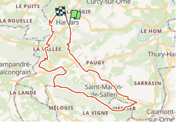
Tocht Stappen van 20 km beschikbaar op Normandië, Calvados, Le Hom. Deze tocht wordt voorgesteld door UDGI54.
Plaatsbepaling
Land:
France
Regio :
Normandië
Departement/Provincie :
Calvados
Gemeente :
Le Hom
Locatie:
Hamars
Vertrek:(Dec)
Vertrek:(UTM)
679524 ; 5430071 (30U) N.
Opmerkingen